Showing posts with label Pikes Peak geology.. Show all posts

Wednesday, September 27, 2017

A GRANITE BOULDER TAKES A RIDE IN UTE PASS

 By Steven Wade Veatch

With the suddenness of a rattlesnake’s strike, an enormous boulder of Pikes Peak Granite moved down one of the steep slopes of the lower part of Ute Pass, Colorado. As this rock—larger than a yellow school bus—traveled down the hill, it flattened the bushes growing in front of it, and left a trail of scraped ground behind it.

Figure 1. Gravity’s relentless force pulled this huge boulder
down the hill to its resting place near US Highway 24
between mile marker 295 and 296. This is a geohazard.
Photo © S. Veatch.
This giant rock, perched on a slope in Ute Pass along US Highway 24— between Manitou Springs and Green Mountain Falls—moved downslope from the pull of gravity in a type of erosion called mass wasting. When combined with the water of winter snow melt or rain that alters ground conditions, gravity can move rocks downhill—the steeper the slope, the faster the rocks and boulders move (McGeary, Brown, & Plummer, 1992).

During a recent summer, thunderstorms poured rain on the pass.  The slope where this boulder rested was saturated with water, making the ground a muddy, slippery mess. As the rain soaked into the soil, it filled pore spaces, which pushed apart individual grains in the soil—decreasing the resistance of the boulder to movement (Murck, Skinner, & Porter, 1997). Also, some of the grass was washed away by rivulets and rills running downslope, also adding to the conditions that mobilized the boulder.

One night when it was quiet, except for the rasp of a cricket and the passing of an occasional car on the highway, the force of gravity became greater than the resistance of the ground holding the immense boulder in place. Catching the sleeping birds in the pine trees off guard, the giant rock yielded to the endless pull of gravity and slid down the slope—a geological event that starts within the blink of an eye.

Figure 2. A once moving boulder left behind a trail and pushed up
loose gravel in front of it as it slid down the slope of Ute Pass.
Photo © S. Veatch.
This rapid movement of rocks is a geohazard that develops over time and locally impacts Ute Pass and Manitou Springs. Ute Pass and Manitou Springs are in the path of sliding and falling rocks. Work is ongoing to mitigate some of these hazards. Travelers going through Ute Pass not only have to watch other drivers, but must also look out for moving boulders.

References
McGeary, D., Brown, W. C., & Plummer, C. C. (1992). Physical Science: Earth Revealed. Dubuque: William C. Brown.

Murck, B. W., Skinner, B. J., & Porter, S. C. (1997). Dangerous Earth: An Introduction to Geologic Hazards. New York: John Wiley & Sons, Inc.




Saturday, December 12, 2015

PIKES PEAK REGION’S ICONIC ROCKS

By Steven Wade Veatch

Steamboat Rock and Balanced Rock are well-known tourist attractions in the heart of the Garden of the Gods. These iconic rocks were once privately owned, but today they are part of Colorado Springs’ famous city park.

Steamboat Rock once had steps carved into the rock that went to its top. Tourists eagerly climbed up to the observatory to view the beautiful geological wonders. Balanced Rock, the 700-ton attraction has—for millions years—withstood the inexorable forces of nature, including wind, cycles of freezing and thawing, earthquakes, and relentless erosion. Both scenic rocks are eroded sections of the Fountain Formation, a sandstone composed of unsorted sand and pebbles of many sizes that were washed down from the Ancestral Rocky Mountains.
     
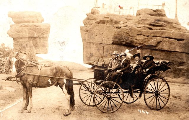
Figure 1. Early photograph of tourists visiting Balanced Rock (R) and Steamboat Rock (L). In this undated photo a man is enjoying the natural beauty of the area with three female companions in a horse-drawn buggy. Curt Goerke, a 14-year-old entrepreneur, began taking photos of tourists in front of the rocks in the 1890s, selling them each for 25 cents. Photo from the collection of S.W. Veatch.


Figure 2. This view of Steamboat Rock, on a postcard, was taken  about 40 years later than the image in figure 1. Few changes are noted in the physical condition of Steamboat rock. A sign read, “Steamboat Rock Observatory. Use of the telescopes free to visitors. All welcome.” Photo from the collection of S.W. Veatch.
The Fountain Formation began to form long before the dinosaurs roamed Colorado.  A rapid mountain uplift, known as the Colorado Orogeny, began 300 million years ago that produced an ancestral range of Rocky Mountains.  Rain and intense thunderstorms produced torrents of water with enough energy to move rock, ranging in size from tiny grains to large clasts.  These eroded sediments—from the Ancestral Rockies nearby to the west—piled up at the base of these ancient mountains as gravels and formed the Fountain Formation.  This rock unit, up to 4,500 feet thick, has a deep red color from the chemical alteration of iron minerals.  The rock fragments in the Fountain Formation are angular indicating the fragments were not deposited far from their sour

A number of the Garden of the God’s landmarks, including Steamboat Rock and Balanced Rock, were shaped by erosion.  Erosion continues today.
     
About the author: Steven Veatch is a writer and geoscientist. His family came to the Cripple Creek and Victor Gold Mining District in the early 1890s where they mined for almost more than three decades. The other side of his family mined in the Caribou District in Boulder County, Colorado. Veatch lives next to the Florissant Fossil Beds National Monument.